Python实现经纬度坐标距离与方位角计算

发布时间:2026-10-14| 6人浏览过
本文介绍利用Python计算设备经纬度坐标间距离及角度的方法。通过引入地球椭球参数,实现高精度距离与方位角算法,并提供完整代码示例。经深圳野生动物园至坪山站实测,计算结果与百度、Google地图测距基本一致,验证了算法的有效性。
Python经纬度坐标转换概述
近期项目中遇到一项需求,需根据设备提供的经纬度坐标计算两点间的距离及相对角度。经测试验证,该方案效果良好,现整理分享。
距离计算代码实现
一、经纬度距离计算代码
#!/usr/bin/env python
# -*- coding: utf-8 -*-
__author__ = 'Seven'


import math


# 计算距离
def getDistance(latA, lonA, latB, lonB):
  ra = 6378140 # 赤道半径
  rb = 6356755 # 极半径
  flatten = (ra - rb) / ra # Partial rate of the earth
  # change angle to radians
  radLatA = math.radians(latA)
  radLonA = math.radians(lonA)
  radLatB = math.radians(latB)
  radLonB = math.radians(lonB)

  pA = math.atan(rb / ra * math.tan(radLatA))
  pB = math.atan(rb / ra * math.tan(radLatB))
  x = math.acos(math.sin(pA) * math.sin(pB) + math.cos(pA) * math.cos(pB) * math.cos(radLonA - radLonB))
  c1 = (math.sin(x) - x) * (math.sin(pA) + math.sin(pB)) ** 2 / math.cos(x / 2) ** 2
  c2 = (math.sin(x) + x) * (math.sin(pA) - math.sin(pB)) ** 2 / math.sin(x / 2) ** 2
  dr = flatten / 8 * (c1 - c2)
  distance = ra * (x + dr)
  distance = round(distance / 1000, 4)
  return f'{distance}km'
角度计算代码实现
二、经纬度角度计算代码
#!/usr/bin/env python
# -*- coding: utf-8 -*-
__author__ = 'Seven'

import math

# 计算角度
def getDegree(latA, lonA, latB, lonB):
  radLatA = math.radians(latA)
  radLonA = math.radians(lonA)
  radLatB = math.radians(latB)
  radLonB = math.radians(lonB)
  dLon = radLonB - radLonA
  y = math.sin(dLon) * math.cos(radLatB)
  x = math.cos(radLatA) * math.sin(radLatB) - math.sin(radLatA) * math.cos(radLatB) * math.cos(dLon)
  brng = math.degrees(math.atan2(y, x))
  brng = round((brng + 360) % 360, 4)
  brng = int(brng)
  if (brng == 0.0) or ((brng == 360.0)):
    return '正北方向'
  elif brng == 90.0:
    return '正东方向'
  elif brng == 180.0:
    return '正南方向'
  elif brng == 270.0:
    return '正西方向'
  elif 0 < brng < 90:
    return f'北偏东{brng}'
  elif 90 < brng < 180:
    return f'东偏南{brng - 90}'
  elif 180 < brng < 270:
    return f'西偏南{270 - brng}'
  elif 270 < brng < 360:
    return f'北偏西{brng - 270}'
  else:
    pass
实际案例验证
三、效果验证
选取深圳野生动物园(坐标:22.599578, 113.973129)作为起点,深圳坪山站(坐标:22.6986848, 114.3311032)作为终点,结合百度地图与谷歌地图进行对比验证。
程序运行输出结果如下:
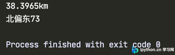
百度地图测距显示为38.3km
谷歌地图手动测距显示为39.31km
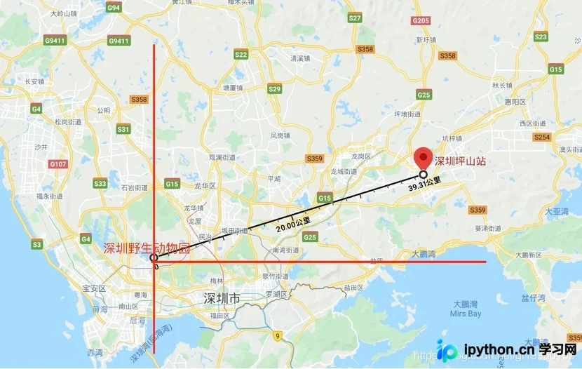
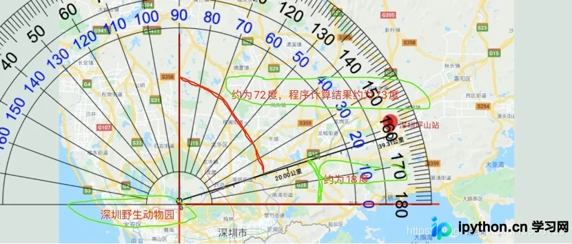
计算得出的距离与角度均符合预期,无异常。
以上就是关于Python经纬度坐标转换为距离及角度的实现方法,更多相关技术内容可搜索本站往期文章或关注后续更新,感谢支持。
免责声明:本文内容仅供参考,不代表本站观点。转载或引用请注明出处。